


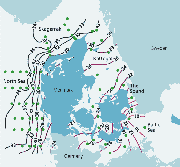
| Map of Danish marine waters | ||
 |
Figure
2.5
|
 |
| Figure
2.6 Interpolated distribution of surface salinity (mean 1-10 m) in February 2002.
|
 |
| Figure
2.7 The development of annual mean surface (0-10 m) temperature in Kattegat 1970-2000.
|
Hydrography
The Danish marine area is very diverse and includes many semi-enclosed estuaries and fjords, open estuaries and bights, narrow straits, semi-enclosed seas as the Baltic and Kattegat and open shelf seas as the Skagerrak and North Sea (see Map of the Danish Marine Waters).
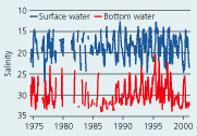
The annual freshwater net surplus of about 475 km3 from the Baltic Sea passes through the Danish straits (Sound and Belt Sea) and Kattegat to the Skagerrak/North Sea. The salinity of the outflowing Baltic water is about 8 and forms a brackish surface layer in the transition area with the salinity increasing to 25-30 at the Skagerrak border due to mixing with saline bottom water. High saline Skagerrak water flows as bottom water into the Kattegat and Belt Sea. This creates a strong halocline in 13-15 m depth, which is re-enforced by a thermocline during summer. The salinity in the Kattegat – Belt Sea area has a general seasonal variation with the highest salinity in the surface and lowest in the bottom water during winter (Figure 2.5).
The German Bight annually receives about 37 km3 freshwater from the rivers Elbe and Weser (mean 1980–86), and the southern North Sea Bight about 81 km3 from the Rhine (Gerlac 1990). The Jutland Coastal Current annually transports about 1,500 km3 water from the German Bight to the Skagerrak. The runoff to the Southern North Sea causes a salinity in the Jutland Coastal Current to be about 28–30 when it enters the Danish coastal waters in the German Bight. The salinity increases northward along the Danish coast as it is mixed with central North Sea water. The salinity distribution in the surface of the open Danish waters is shown in Figure 2.6.
The salinity in the estuaries and fjords depends on the amount of freshwater received, residence time and the salinity of the coastal water outside the estuary. Most of the Danish estuaries are shallow with only periodic stratification due to inflow of saline bottom water or establishment of a thermocline during calm and warm periods. Some fjords, such as Mariager Fjord, Flensborg Fjord and the deep open Åbenrå Fjord have permanent haloclines.
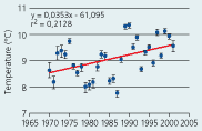
The seasonal amplitude of the surface temperature in open waters goes
from 1-4°C in winter to 15–20°C in summer. The variation
in the bottom water is from 4°C to 11°C. The annual mean surface
temperature in Kattegat has increased significantly from 8.5°C to
9.6°C in the period 1970–2000 (Figure
2.7).
| | Top | |
| Next
| |