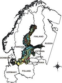
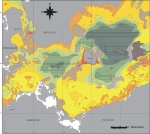
Sediment maps of the Baltic Sea
Coverage of the Baltic Sea bottom
by sediment maps:
Overview map of the Baltic
sediments |
|
|
Winterhalter, B., Ignatius, H., Axberg, S., Niemistö, L. (1981):
Geology of the Baltic Sea. In: Voipio, A. (Editor), The Baltic Sea.
Oceanography Series. Elsevier, 121pp.
Digitalised version supplied by:
B. Bobertz,
Baltic Sea
Research Institute (IOW) Germany
Gelumbauskaite, L.Y., Grigelis, A., Cato, I., Repecka, M. & B. Kjellin (1999): LGT Series of Marine Geological maps No.1. SGU Series of Geological Maps Ba No. 54.
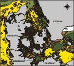
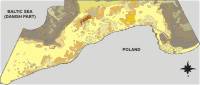
Hermansen, B. & J. B. Jensen (2000): Digital Sea Bottom Sediment Map around Denmark. Danmarks og Groenlands Geologiske Undersoegelse, Rapport 68, 2000.
This map is based on the map of Hermansen, B. & J. B. Jensen
(2000): Digital Sea Bottom Map around Denmark. Geological Survey
of Denmark and Greenland, Kopenhagen and data of the German Federal
Office for Shipping and Hydrography (BSH).
H-Ch. Reimers
State Agency for the Environment, Nature Conservation and Geology
of Mecklenburg-Western Pommerania (LUNG), Germany.
(unpublished)
State Office for Environment and Nature in Rostock (STAUN) Rostock,
GIS Küste M-V. Version 2.0, 05.01.2000.
Provided by:
L. Tiepolt
State Office for Environment and
Nature in Rostock (STAUN) Rostock, Germany.
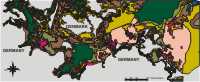
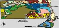
Emeljanov, E., Neumann, G. & W. Lemke (1993): Bottom Sediments of the Western Baltic. Baltic Sea Research Institute (IOW), Germany
P.P.Shirshov Institute of Oceanology RAS, Atlantic Branch, Russia.
- Tauber, F., Lemke, W. & R. Endler (1999): Map of sediment
distribution in the Western Baltic Sea (1:100.000), sheet: Falster-Moen.
Deutsche Hydrographische Zeitschrift, 51, 1, pp. 5-32.
- Tauber, F. & W. Lemke (1995): Map of sediment distribution
in the Western Baltic Sea (1:100.000), sheet: Darss. Deutsche
Hydrographische Zeitschrift, 47, 3, pp. 171-178.
- Bobertz, B. (1996).Untersuchen der regionalen Verteilung granulometrischer
Eigenschaften der Oberflächensedimente der Pommernbucht mit geostatischen
Verfahren und ihre genetische Interpretation. Diploma Thesis,
Ernst-Moritz-Arndt-Universität Greifswald, pp. 53pp.
Geological Map of the Baltic Sea Bottom. 1:200 000. J. E. Mojski (scientific editor). Polish Geological Institute, Warsaw, 1989-1995, (17 sheets)
Digitised version provided by:
J. Urbanski,
Gdansk University, Poland
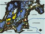
Gulbinskas, S. (1995): Recent Bottom Sediment Distribution in
the Curonian Lagoon - Baltic Sea Sedimentary Area. Geografijos metrastis,
t. 28 Vilnius, pp. 296-314.
Digitised by:
M. Popova, Coastal Research and Planning Instiute, Klaipeda University,
Lithuania.
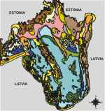
Striebrins, O. & P. Valing (1996): Bottom Sediments of the
Gulf of Riga. 1: 200 000. Riga, 54 pp.
Digitised by:
Institute of Aquatic Ecology, University of Latvia.
Finland
detailed maps for
selected regions |
|
|
1a-d Rantataro, J. (1992): Mapping of Sea Floor Deposits
Offshore Helsinki Region C31. ISBN 952-9567-08-1. ISSN 0357-3214.
2. Häkkinen, A. (1989): Seafloor Sand and Gravel Investigations
on Gullkrona fjärden, The Archipelago Sea, 1989. Turku 1990.
ISBN 952-9532-07-5.
3. Lehtoranta, J.: Unpublished map of the accumulation areas offshore from Tammisaari region. Finnish Environment Institute and Geological Survey of Finland.
Prepared by:
Baltic Sea Research Institute (IOW), Germany
Seestrasse 15, 18 119 Rostock-Warnemuende
E-mail: magdalena.wielgat@io-warnemuende.de
|
|