


| Map of Danish marine waters | ||
| Open sea areas | ||
| Coastal areas | ||
| Kills of macrozoobenthos | ||
| Figure 2.38 |
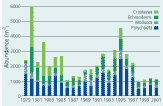 |
| Temporal development of abundance at 3 stations of 17-55 m water depth, in the Kattegat-Sound-Belt Sea area partitioned on major taxonomic groups. Bristleworms (Polychaeta), Molluscs (Mollusca), Echinoderms (Echinodermata) and Crustaceans (Crustacea). Remaining taxa had a negligable part of the total abundance. Note the dramatic decrease in numbers of crustaceans over the 2 decades. |
Softbottom macrobenthos
Benthic macrofauna in soft sediments plays an important role in the degradation of organic matter produced in the pelagic zone and several species serve as food for demersal fish. Since it is composed of many different species (in the Kattegat there are more than 500 species), benthic macrofauna furthermore constitute a great part of the biodiversity in the water surrounding Denmark. The macrofauna integrates environmental changes in the benthic environment and is a highly cost effective parameter to sample. Moreover, since this fauna often is limited by food, such as sedimenting phytoplankton biomass, macrozoobenthos is a useful parameter to describe changes in eutrophication.
Benthic macrofauna has been included in the Danish Monitoring Programme since 1979 and is measured with replicated quantitative sampling at fixed stations. Number of individuals and biomass (wet weight or dry weight) are measured for each species. Sampling occurs once a year typically in May/June. The number of fixed stations regularly visited at present include 24 stations in open sea areas mainly in the Kattegat and station grids in 22 estuaries and near coastal areas around Denmark.
OPEN SEA AREAS
General trends in macrozoobenthos abundance in the Sound, the Kattegat
and the Belt Sea follow a bimodal pattern over the last 20 years with
peaks in the beginning of the 1980s and in the middle of the 1990s (Figure
2.38). While the first peak was dominated by both polychaetes and
crustaceans, the peak in the 1990s was only dominated by polychaetes.
Within the taxonomic groups different species dominated in different peaks
and at different stations. Biomass did not show the same clear pattern
as abundance. Biomass and total abundance showed the lowest values in
the period 1998–2001 since the measurements started.
Over the two last decades changes in total abundance and biomass of macrobenthos are below the halocline in Danish open sea areas. Correlation analyses performed between the biological variables and two environmental variables related to climate, the North Atlantic Oscillation index (NAO-index) and runoff of freshwater from Denmark, showed significant positive correlation with a 1 or 2 years time lag, indicating influence of climate on benthic variations (Henriksen et al. 2001). In particular winter nutrient input, and the spring phytoplankton bloom, most likely influences the abundance of benthic macrofauna.
However, correcting for the linear effects of runoff, the general pattern in abundance is still there, suggesting the importance of other factors hitherto not identified. Some evidence indicates that reduced nitrogen nutrient concentrations and possibly reduced diatom abundance, when corrected for runoff, may have reinforced the decrease in benthos stocks in recent years.
COASTAL AREAS
From 1998 the monitoring strategy for estuaries and coastal areas was
changed from measurements on single stations to measurements on grids
of stations in each area. Benthic fauna data sampled with consistent methods
are now available from 25 different estuarine and bay areas from the period
1998 to 2001. Unlike the open Kattegat and the Belt Sea, where faunal
changes in total abundance and biomass to a large degree are synchronised
between stations, changes in coastal areas do not seem to be synchronised
to the same degree. This is exemplified in Table 2.10
where total number of species in the 4 years are shown for each coastal
area. The number of areas with increasing species numbers are about the
same as the decreasing ones. Reasons for lack of synchrony between coastal
areas is probably local factors like oxygen deficiency. For example, in
Mariager Fjord fauna was more or less exterminated by oxygen deficiency
in 1997 and thereafter a succession of species have taken place reflected
by increasing number of species. In conclusion, there are no general synchronous
changes in abundance, biomass or number of species in coastal areas over
the last 4 years.
KILLS OF MACROZOOBENTHOS
The increase in oxygen consumption due to enhanced loads of organic matter
to the bottom can lead to oxygen depletion and death of benthic fauna.
Though these events are not part of the monitoring programme, many of
the events are still recorded (see Table 2.11).
There are examples from Danish marine areas, like the southern Little Belt, where severe acute oxygen depletion and probably kills of macrobenthos have been an almost regular yearly event since the beginning of the last century. However, the area in the southern Little Belt where macrobenthos suffer from oxygen depletion is in recent years five times larger than 100 years ago (Marin ID 1988). Large scale oxygen depletion events with kills of macrobenthos belong to the present. A well known example is from 1986 when fishermen caught dead Norwegian lobsters (Nephros norvegicus) in the Kattegat. It is also likely that 2002 will be well-known for the extended oxygen depletion and resulting kills of macrobenthos.
Table 2.10
Changes in macrofauna species numbers 1998-2001
in 25 coastal areas in Denmark. The first coloumn denotes total sampling
area.
![]() denotes a decrease
compared to previous sampling
denotes a decrease
compared to previous sampling
![]() denotes an increase
denotes an increase
![]() denotes no difference
denotes no difference
| Coastal area | m |
1998 |
1999 |
2000 |
2001 |
| Roskilde Bredning | 0.51 |
29 |
29 |
23 |
30 |
| Horsens Fjord | 0.61 |
- |
24 |
24 |
40 |
| Vejle Fjord | 10.07 |
- |
52 |
36 |
55 |
| Kolding Fjord | 5.54 |
- |
57 |
36 |
61 |
| Ringkøbing Fjord | 7.15 |
20 |
22 |
22 |
17 |
| Nissum Fjord | 6.44 |
30 |
29 |
33 |
28 |
| Hevring Bugt | 5.54 |
76 |
69 |
87 |
91 |
| Øresund | 6.44 |
68 |
51 |
54 |
52 |
| Køge Bugt, central part | 6.44 |
26 |
30 |
28 |
35 |
| Odense Fjord | 6.45 |
66 |
78 |
57 |
57 |
| Ringgårdbassin | 5.81 |
27 |
28 |
25 |
19 |
| Roskilde Fjord, northern part | 3.58 |
33 |
30 |
31 |
37 |
| Isefjord | 3.15 |
24 |
36 |
19 |
15 |
| Kattegat | 2.86 |
63 |
51 |
61 |
66 |
| Lillebælt | 5.54 |
35 |
50 |
51 |
27 |
| Karrebæksminde Bugt | 6.57 |
40 |
28 |
37 |
31 |
| Skive Fjord | 6.44 |
31 |
36 |
24 |
41 |
| Nissum Bredning | 6.44 |
33 |
31 |
49 |
34 |
| Løgstør Bredning | 6.44 |
42 |
34 |
32 |
35 |
| Wadden Sea, northern part | 26.66 |
43 |
43 |
41 |
47 |
| Århus Bugt | 6.03 |
62 |
46 |
54 |
57 |
| Mariager Fjord | 5.54 |
17 |
14 |
28 |
26 |
| Flensborg Fjord | 5.41 |
66 |
30 |
30 |
17 |
| Wadden Sea, southern part | 1.98 |
41 |
36 |
43 |
40 |
| Nivå Bugt | 3.58 |
- |
62 |
65 |
57 |
| Average species numbers | 41.524 |
39.84 |
39.6 |
40.6 |
Table 2.11
Recorded macrozoobenthos kills and their causes
in Danish marine waters 1981-2003. Find the location of places at Map
of Danish marine waters.
| Year | Place | Cause |
| 1981 | North Sea, Hevring Bugt, Århus Bugt, Pæregård
Strand, Dalby Bugt, Kalø Vig |
Oxygen depletion |
| 1983 | Lillebælt, Kieler Bugt | Oxygen depletion |
| 1985 | Kattegat | Oxygen depletion |
| 1986 | Kattegat, Kieler Bugt | Oxygen depletion |
| 1987 | Sejerø Bugt, North coast of Sjælland, southern Lillebælt | Oxygen depletion |
| 1988 | Skagerrak, Kattegat | Harmful algal bloom |
| 1988 | Southern Kattegat, Limfjord, Århus Bugt, | Oxygen depletion |
| 1989 | Horsens Fjord | Oxygen depletion |
| 1990 | Århus Bugt, Northern Lillebælt | Oxygen depletion |
| 1991 | Haderslev Fjord | Oxygen depletion |
| 1992 | Haderslev Fjord | Oxygen depletion |
| 1993 | Vejle Fjord, Southern Lillebælt | Oxygen depletion |
| 1994 | Roskilde Fjord, Limfjord, Vejle Fjord, Nørrefjord, Flensborg Fjord, Sydfynske Øhav, Isefjord, Århus Bugt, Åbenrå Fjord, Genner Fjord, Flensborg Fjord, Lillebælt |
Oxygen depletion |
| 1995 | Åbenrå Fjord, Roskilde Fjord | Oxygen depletion |
| 1996 | Limfjorden, Vejle Fjord, Lillebælt | Oxygen depletion |
| 1997 | Mariager Fjord, Limfjorden, Nakkebølle Fjord, South and east
of Møn, Isefjord |
Oxygen depletion |
| 1998 | Southern Lillebælt, Åbenrå Fjord Flensborg Fjord | Oxygen depletion |
| 1999 | Limfjord, Kalø Vig, Knebel Vig, Århus Bugt, Horsens Fjord, Vejle Fjord, Flensborg Fjord, sydlige Bælthav, Sydfynske Øhav |
Oxygen depletion |
| 2000 | Langelandssund, Ebeltoft Vig, Århus Bugt, Odense Fjord, Limfjorden |
Oxygen depletion |
| 2001 | Limfjorden, Århus Bugt | Oxygen depletion |
| 2002 | Limfjorden, Århus Bugt, Hevring Bugt, Mariager Fjord, Oxygen
depletion Vejle Fjord, Ålborg Bugt, Kalø Vig, Åbenrå Fjord, Flensborg Fjord, coastal areas north and south of Fyn, Lillebælt |
Oxygen depletion |
| | Top | |
| Next
| |